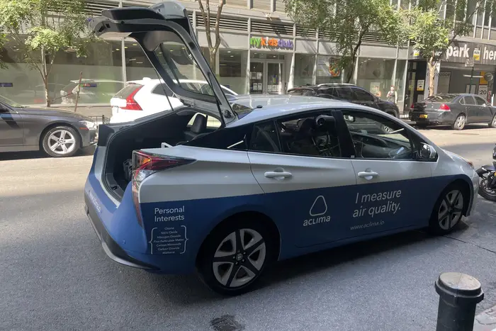
Stuck in traffic on Broadway near City Hall — like any other car in lower Manhattan on a hot August morning — is an ordinary-looking bright blue and white Toyota Prius.
That is, until it pulls up and you see the words “I measure air quality” written on the driver’s side door.
The car is sucking in air through clear plastic tubes that run through the rear window and into a little mobile laboratory arranged neatly like catalog luggage in the trunk.
For the next year, more than 20 of these labs on wheels will be deployed in a pilot program run by the New York State Department of Environmental Conservation. The fleet is part of a statewide campaign to reduce greenhouse gas emissions locally and improve urban air quality in accordance with state climate laws, which require enhanced air monitoring.
“Right now, we measure temperature, black carbon, carbon dioxide, humidity, pressure, ozone, nitrous oxide, nitrogen dioxide, carbon monoxide, fine particulate matter…,” said the car’s driver Ramses Diaz, listing some of the pollutants and metrics they record as he cruises through downtown. The vehicle can quantify about 20 different emissions.
Target areas include Manhattan, the Bronx, Albany and Buffalo/Niagara. Within a year, people living in these places will be able to go online and find their homes and workplaces, and see what kind of air they are breathing when they walk out the door. While regulations on heating oil and other pollutants have led to markedly cleaner air in cities than in decades past, environmental leaders say there’s much work yet to be done.
“There are holdouts — areas of extreme pollution,” said Basil Seggos, the DEC commissioner. “Really the purpose of going down to the street level is to find out what people are breathing on the street, in their homes, in their backyards, and then use that data ultimately to drive better decision-making.”
In the trunk is "where the magic happens" according to Aclima's fleet manager, Erald Xhaferaj. The big black box measures methane. The smaller box is the black carbon instrument. The data is measured every second and sent in real time.
Each device placed in the cars’ trunks measures a different set of air pollutants as the vehicles drive along. This data is sent in real time along with geographical locations to scientists in San Francisco. The environmental tech company Aclima then catches, uploads, and analyzes the data as part of its contract with the DEC.
Previously, the agency relied on stationary monitoring units located on buildings throughout the city, but those sites didn’t provide enough resolution to find the worst hotbeds or local sources of pollution. They could measure the environmental burden for a large community but not pinpoint the homes, buildings, and people that were most harmed.
The problem with a central monitoring point, according to Dr. Joan Casey, an environmental health sciences professor at Columbia University’s Mailman School of Public Health, said that there are usually only one to five of these sites in a city. Sometimes, there is only a single device measuring the air quality for a million people.
“We know that the level of air pollution isn't consistent across an entire city, so we can be missing a lot of really important things if we only rely on a single central air pollution monitor,” Casey said.
They have limitations, too. Fixed, immobile monitors can miss air pollutants. Nitrogen oxides, for example, are emissions that are only elevated within a half-mile of a roadway. A sensor placed beyond this range won’t pick up the hazard.
What’s bad about New York’s air?
Local stationary monitoring stations can already tell regulators that more than 22.5 million people are breathing bad air across the New York City metropolitan area despite an improvement in quality in recent years. Just over half are people of color, according to the State of the Air report released in November of last year.
A bundle of clear tubes draws air from outside and brings it through the rear window to connect to machines in the trunk that reads the levels of about 20 air pollutants.
One of the biggest concerns is ozone, which resulted in a failing grade for air quality for the area. Even at low levels, ozone can exacerbate respiratory conditions such as asthma. One of its main components, nitrogen oxides, can travel far distances. It can contaminate water and land. It contributes to global warming and can lead to heart disease.
Power plants and gas-powered vehicles are mostly responsible for these emissions, but lots of smaller sources burn fossil fuels, too. An idling diesel-fueled school bus can cause a street-level spike in black carbon – a sooty pollutant that comprises a significant portion of particulate matter. Black carbon and particulate matter have been linked to a long list of health problems, including birth defects and cancer.
This inlet is on the rear window of the Aclima air monitoring vehicle. Inside, there are clear plastic tubes, which suck in outside air and deliver it to machines in the trunk for analysis.
“NOx [nitrogen oxides] or black carbon or a volatile organic compound might have a much more local scale for how it's distributed,” Casey said. “Some of these pollutants will benefit more from being tracked by these cars than others.”
Erald Xhaferaj, the fleet manager at Aclima, said the maps his team is building will provide “better visuals of the pollution, because what essentially we are building is visual maps of the pollution in the air.”
Laboratories on Wheels
Six more communities will launch in the fall, as early as next month, which includes Rochester, Syracuse, Mount Vernon/Yonkers, Brooklyn, Queens, and Hempstead
Seggos estimates that about 5 million people will receive this monitoring at an initial cost of $11 million annually. The project is mostly funded through a grant from the New York State Energy Research and Development Authority as part of the regional greenhouse gas initiative, the same tool the state used to reduce power plant emissions. Just over a quarter of the funding comes from monies allocated by Gov. Kathy Hochul.
“For a year plus of work, this is far more efficient, far less dollars that would’ve been spent were we as a state to try to do this on our own,” Seggos said.
Before the Aclima air monitoring program, the DEC would have to go to great lengths to figure out the pollution contributors in an individual community.
In 2017, the agency tried to find what was causing a surge of air hazards near a public housing campus in Albany’s South End. In addition to black carbon and particulate matter, a stationary tower had detected nitrogen dioxide and cancer-causing benzene.
Aclima driver Ramses Diaz drives the morning shift through lower Manhattan, measuring air temperature in real time while listening to Brian Lehrer. Erald Xhaferaj (right), Aclima’s fleet manager, stands on the other side of the laboratory, which processes air quality readings and is located in the car’s trunk.
Originally, regulators thought it was the dramatic increase in rail traffic containing crude oil from the Midwest.
To find answers, the DEC deployed an “extraordinary number of staff and volunteers” over an eight-month period with backpack air monitors. The project cost $500,000.
“These folks actually walked about the distance between Albany and Washington D.C. [over the course of the project],” Seggos said. “That knowledge that we gained resulted in a fairly dramatic shift in the way that we proposed to handle truck traffic.”
It turned out that the trains carrying long hauls of crude oil were not the local heavy pollution source. It was the trucks, and as a result, this fleet of traffic was rerouted through the port, away from homes.
The Aclima air monitoring program will work in a similar fashion, but more efficiently. Drivers will follow a specific route that changes daily, but every block will get about 20 passes at different times of day and year to get more detailed and accurate readings.
Some pollutants are higher at different times of day — or on certain days of the week. Air contaminant levels also change seasonally. Ozone is higher in the summer, while nitrogen oxides peak in the winter. Every data point has a timestamp and a GPS location, so the results can help build real-time maps.
Aclima drivers receive a daily driver's plan detailing the path they must drive that day. Every point in the test area is passed at least 20 times at different times, days of the week, and seasons. All these data points are important clues in finding hot spots and pinpointing their sources.
The system was conceived by Aclima’s founder, Davida Herzl. The company’s devices are intentionally designed to be the same size as carry-on luggage so that they fit neatly in the car’s trunk. The devices are embedded with a number of small-scale air quality sensors that measure multiple emissions every second.
Data this granular is intrinsic to improving air quality. Melissa Lunden, Aclima’s chief scientist, said that pollution concentrations can vary dramatically from one block to the next, as much as eight times more, and oftentimes that means the source is somewhere on that block.
“On a neighborhood level, even restaurants, metal recyclers or auto shops can be sources. It really helps put a magnifying glass close to where people live,” Lunden said.
By early fall 2023, the DEC said the public will be able to go online, type in an address and see the actual air pollution levels right outside of their homes and offices — for any time of day or year.
“It can help us uncover places that are more polluted than we thought,” Casey said, and then hopefully be able to do something about it.
This story was updated to correct the spelling of Joan Casey’s first name.