On the morning after Hurricane Sandy, I decided to bike along the coast of Brooklyn to see what had happened during the storm. From my front porch in Sunset Park, I could see the New York Harbor just four blocks away, but my neighborhood had very little damage.
I wound my way through Gowanus and Red Hook and up to Williamsburg and Greenpoint, visiting communities that I’d been documenting for years. Neighbors were in the streets, pumping out their flooded basements and clearing away fallen trees, flooded cars, and boats. But things did not look all that bad.
Throughout the day, though, news began to slowly trickle in from further out in the city, where dozens of neighborhoods in southern Brooklyn, the Rockaways, and Staten Island had been devastated. As I heard reports of a tanker pushed ashore, destroyed houses, catastrophic fires, and dozens of fatalities, the weight of the storm began to sink in.
Over the weeks that followed, I began visiting these places, many of which I knew from before the storm, to share what had happened. As I climbed over piles of boats that had been pushed ashore and picked my way through marshlands littered with roofs and toys, it felt like visiting a war zone.
Nov. 16, 2012: A charred alleyway runs between burnt ruins of homes in the Breezy Point neighborhood in Queens.
The destruction was immense and difficult to witness: Flooded streets, burnt out blocks, flattened houses, and no electricity or water. At least 43 people died in New York City, and thousands of homes were badly flooded.
Ten years on, the storm’s impacts are still being felt. For the communities that lost homes, neighbors, and loved ones, it has been a long decade of recovery and rebuilding. And in the decade ahead, even more neighborhoods will be upended.
The places that suffered the worst damage are not particularly well known to tourists or even many New Yorkers. They are neighborhoods like Edgemere and Ocean Breeze, where the stormwater filled the streets and rushed through houses. They're gated communities like Sea Gate and Breezy Point, where houses were crushed or burned during the storm. Their recovery has largely occurred out of view, hidden away along the city’s waterfront.
Over the last decade, I’ve visited each of these places many times, talking with neighbors, photographing the incremental changes as the city hardens its coastline, and writing about the difficult process of rebuilding. While it took years for some neighborhoods to recover, others simply never did. After the storm, the initial cleanup was relatively quick, with flooded homes emptied out and personal belongings hauled away by the city. But what came next is still unfolding.
Oct. 9, 2022: Homes in the rebuilt Breezy Point neighborhood in Queens.
Rebuilding and retreat
In Breezy Point, a private community at the western tip of the Rockaways, hundreds of homes were flooded during the storm, and one section burned to the ground. It was a difficult decision to take photos here after the storm, because the devastation was so terrible.
But by Sandy’s fifth anniversary, the burned-out streets had been almost entirely rebuilt – with older homes elevated atop concrete stilts or replaced by new multistory structures built on the narrow lots. Today, the storm-damaged sections of Breezy Point — as well as similar neighborhoods like Broad Channel and New Dorp Beach — are nearly unrecognizable. The narrow streets, once filled with simple bungalows, have been transformed.
In Sea Gate, at the western end of Coney Island, the storm slammed into beachfront mansions, destroying seawalls and hollowing out homes. On my first visit two weeks after the storm, I remembered thinking, “How can you ever recover from this?” Houses were collapsing as the ocean lapped at their doorsteps.
Nov. 11, 2012: A beachfront mansion in the Sea Gate neighborhood of Coney Island, in Brooklyn.
After a lengthy cleanup, Sea Gate has now been almost fully rebuilt. Walking along the coast today, one can see new houses, new coastal barriers, and a replenished beach. But most homes are protected by their own individual seawalls, which are sometimes nothing more than piles of broken concrete in the front yard.
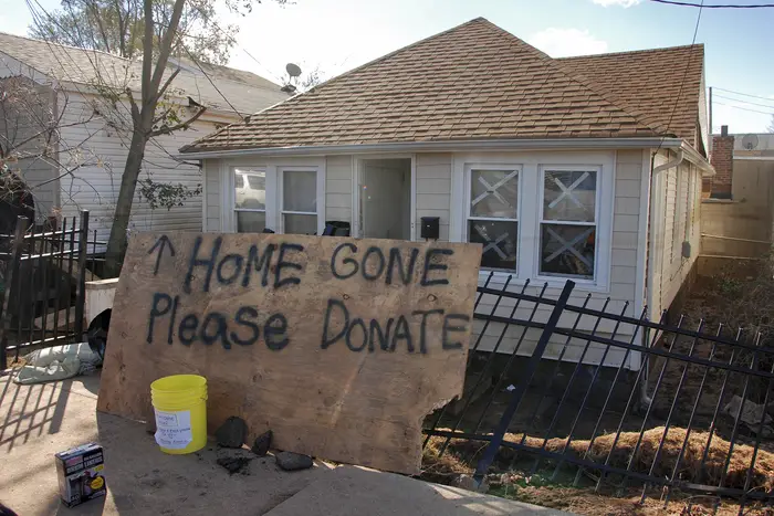
In Staten Island, residents of three neighborhoods that were decimated by Hurricane Sandy became frustrated at the slow process of rebuilding, opting to sell their homes to the New York state government as part of a buyout and relocation program. Over the past 10 years, I’ve documented the entire process of this managed retreat in photo essays and a short film, as houses in Oakwood Beach, Ocean Breeze, and Graham Beach have been demolished and turned back into wetlands.
The demolitions were brutal to observe, with people allowing their family homes to be knocked down and torn to pieces. Walking through these neighborhoods today is almost indescribably sad. The landscape feels like a ghost town, now almost entirely empty, with few reminders of its past. What was once a community has been destroyed twice: first by the storm and then by choice.
Oct. 7, 2022: Rebuilt mansions behind a coastal barrier in Brooklyn's Sea Gate neighborhood.
The unprotected coastline
In other places, a certain kind of entropy has set in. On the shores of Edgemere, a Rockaway neighborhood that has been neglected by the city for decades, nothing substantial has been done to protect against the next storm. Year after year, the waters of Jamaica Bay have continued to lap at the ends of the streets as dozens of empty lots owned by the city have become overgrown marshlands.
A post-storm resiliency plan was announced in 2017, but very little has changed along this waterfront in the last decade, other than several home demolitions. A de facto managed retreat is now unfolding, but some Edgemere residents continue to say they don’t want to move away from their quiet peninsula.
In waterfront neighborhoods throughout the city, few new protections are in place for the next major storm. Red Hook and the Seaport are barely lined with temporary sand-filled barriers. Coney Island and Jamaica Bay are not really shielded at all.
Houses along the bayside of Edgemere, a neighborhood in the Rockaways. The neighborhood, which has been neglected by the city for decades, has not seen any substantial infrastructural development to protect against the next storm.
The only major coastal barrier that has been completed since the storm is a new boardwalk along the oceanfront of the Rockaway Peninsula. It was an impressive construction project, but many other parts of the city would flood again if another Sandy-level storm occurred today.
Maybe the future of New York City’s coastline will look something like Kissam Avenue in Oakwood Beach. The houses are long gone, destroyed by the storm, or demolished afterwards as part of the managed retreat. The marshland has reclaimed the empty lots. Dense stands of phragmites tower over the road, which is pitted with deep potholes. The waterfront has been given back to birds, deer, raccoons, and possums, and humans have moved inland to higher ground. The ocean is slowly eroding the temporary barriers at the end of the street.
Over the past decade, the impacts of Hurricane Sandy have rippled out like waves on a pond, and many neighborhoods are just now starting to experience major changes along their waterfronts. More than $4 billion of new seawalls and coastal barriers that were planned in the aftermath of the storm are now underway, or will break ground soon. The destruction of East River Park in 2021 was a direct result of Sandy. The beach closures in the Rockaways all summer were for the construction of new barriers against storm surges. Wagner Park will also soon be closed off and bulldozed to protect against sea level rise.
Life with climate change
But the biggest changes are still on the horizon. New York is in the final stages of planning for several enormous systems of seawalls, levees, and berms that will transform miles of coastline. These include a seawall along 5 miles of the Staten Island Coast, next to neighborhoods that have already retreated. Even larger projects are planned for the decades ahead, including expanding Lower Manhattan out into the East River, and massive storm surge gates built across a dozen waterways.
These engineering feats across portions of the city’s 520 miles of waterfront could buy us several more decades. As sea levels rise, though, New York will have to again rethink its relationship with the ocean, and what can be saved. Hopefully, it does so in time to act. The water will come again, either way.
Oct. 9, 2022: The coastline of Edgemere in Queens.